


By now, it is understood that COVID-19 is here to stay for sometime. With every passing day, it is becoming more and more difficult to confine ourselves to our homes.
All of us have accepted that we will have to parallelly live with the virus. Since we cannot avoid commuting anymore, Google Maps is here to help.
Google Maps is all set to bring a new update with a COVID-19 filter. It is introducing a COVID layer in Maps which will reflect critical information such as the number of coronavirus cases in an area and more, thereby enabling its users to make informed decisions.
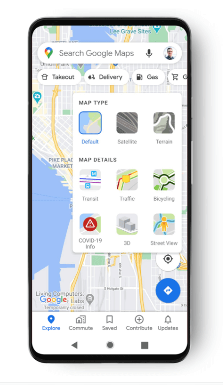
How Does The COVID Layer Work?
After the feature is rolled out, Android and iOS users can turn on the COVID-19 layer in their apps. The Layers button is available on the top right corner of the app and under its drop-down menu, a layer called “COVID-19 Info” will be available.
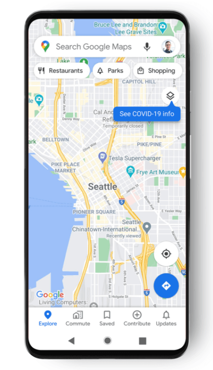
After activating this layer, a user can view the seven-day average of new COVID-19 cases per 100,000 people for the area selected on the map. Along with the average, a label indicating the trend of the cases (increasing or decreasing) will also be visible.
Read Also: How Will Life Look After A COVID-19 Vaccine Arrives?
Furthermore, Google Maps will also reflect the density of new cases in an area through colour coding. The colour coding will be as follows:
- Grey: Less than 1 case
- Yellow: 1-10 cases
- Orange: 10-20 cases
- Dark orange: 20-30 cases
- Red: 30-40 cases
- Dark red: More than 40 cases
Data Sources
Google Maps has also specified the sources from where it collects the data for COVID cases. In a blog post, it has mentioned that it collects data from authoritative sources including The New York Times, Wikipedia, and Johns Hopkins University.
Reportedly, these sources get data from public health organizations like WHO, health ministries, state and local agencies and hospitals. Such data is already available on Google Search and Maps is all set to expand the horizon of this data.
Google Maps has announced that this feature will start rolling out this week and will be available in all 220 countries and territories supported by Maps.
Other than this, in June, Google Maps rolled out an update that alerts commuters on a public transit route if that particular route was affected by various COVID-19 check-in points.
Image Credits: Google Images
Sources: Google Blog, Indian Express, Livemint
Find the blogger: @RitikaaNijhawan
This post is tagged under: COVID-19, Coronavirus, Pandemic, Google Maps, Google Blogpost, Google Maps New Feature, Google Maps New COVID feature, Google Maps COVID layer, Google Maps COVID layer feature, new google maps feature telling covid cases in an area
Other Recommendations:
Websites/Apps Helping Migrant Workers And Laborers Find Jobs Amidst The Pandemic


